Survey and Positioning

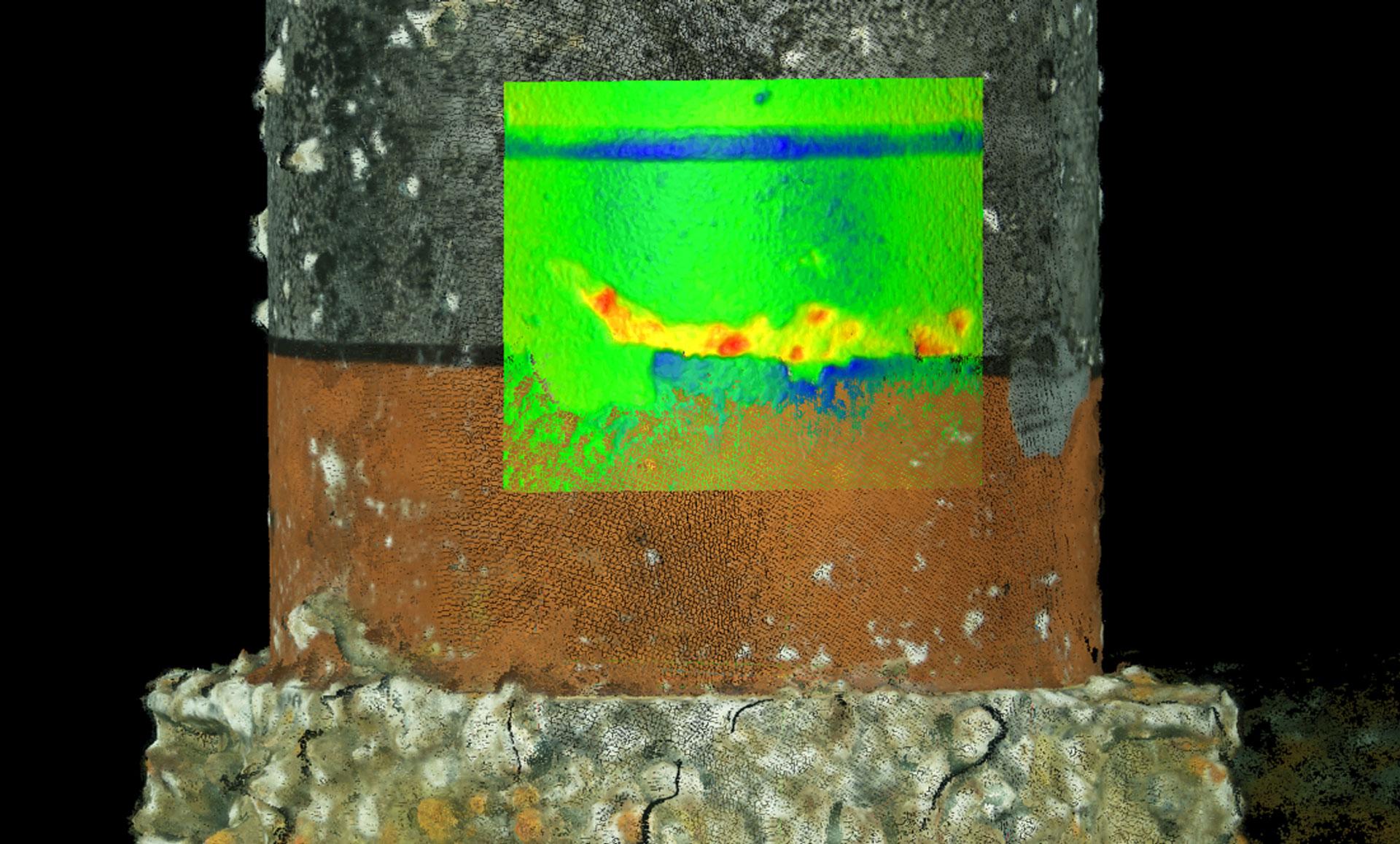
We improve efficiency throughout the marine construction process by providing accurate and precise positioning services for drilling rigs, pipeline lay and derrick barges, and dynamically positioned (DP) multi-purpose construction vessels.

Marine Construction

Our integrated surface positioning solutions combine Oceaneering® C-Nav3050® differential global navigation satellite system (DGNSS) receivers, gyrocompasses, and inertial navigation systems with state-of-the-art navigation software modules.

We offer integrated subsea solutions including ultra-short baseline (USBL) and long baseline (LBL) positioning, subsea gyros, Doppler velocity logs, and a variety of sonar systems for positioning and orienting subsea assets such as wellheads, trees, pipeline end terminations (PLETs), pipeline end manifolds (PLEMs), umbilicals, seabed well templates, flowlines, pipelines, and suction piles.

‎Decommissioning and Abandonment Surveys

Using our own geographic information system (GIS) database, we determine if any evidence of pipelines, hazards, or other subsea infrastructure exists, thus helping you reduce risk during the process. If required, detailed geophysical surveys map or exclude the existence of such hazards and identify appropriate anchoring locations.

We also offer positioning services to anchor vessels during salvage operations. Our surface navigation support continues for the entire decommissioning fleet during removal and subsequent abandonment and reefing operations.

When severing and lifting jackets from the seabed, we use scanning sonar technology to provide positioning services to heavy lift barges along tow routes to avoid existing infrastructure and hazards. Upon completing decommissioning operations, we provide surveys and support, including trawl boat clearance surveys, 360º scanning sonar surveys, diver positioning, and remotely operated vehicle (ROV) positioning.

Diver Survey Support

To support divers and reduce bottom time during surveying, we use acoustic positioning and 360º scanning sonar technology to provide a high-resolution 360° or sector view of the subsea environment. Our system is also used to locate, investigate, and confirm existing hazards or obstacles while providing a dynamic screen presentation of the diver and targets of interest.

We also offer acoustic positioning and other support services, including survey support for pipeline depth-of-burial surveys, along with determination of pipeline locations by using magnetometers and probes, debris searches, and spool piece or jumper installations.

GIS Support

We use our GIS database to investigate route scenarios and isolate publically recognized hazards. The database comprises publically available data researched and assimilated by Oceaneering professionals. Additionally, we can gain further insights by pulling in proprietary survey data.


  • Bureau of Ocean Energy Management (BOEM) and Bureau of Safety and Environmental Enforcement (BSEE) pipeline locations
  • Wells, platforms, artificial reefs, and leases
  • Cultural data
  • Administrative and international boundaries
  • Fairways and anchorages
  • Military warning areas
  • Dump sites
  • Archaeological resource areas
  • Tropical storms (historical and real time)
  • Coastlines
  • Unexploded ordinances and naval mine areas
  • Designated pinnacle trends and live-bottom stipulation areas
  • Marine fisheries and wildlife management areas
  • Outer Continental Shelf (OCS) sediment resource areas
  • Designated hard banks

Pipeline Construction Survey Support

We support the entire pipeline laying process from developing an appropriate route to positioning surface vessels, monitoring the pipeline’s touchdown point, executing post-lay surveys, and reporting.

Prior to pipeline construction, we use our GIS database to evaluate the proposed route for layout dimensions, alignment configuration, and hazard identification. In addition to positioning pipelay barges, we also provide remotely operated vehicle (ROV) positioning for pipeline touchdown monitoring and pre-route inspection.

Additionally, we provide USBL and LBL positioning, positioning for as-built surveys, depth-of-burial surveys, mat placement, and any pipeline activity requiring surface or subsea positioning.

Remotely Operated Survey

We offer an integrated ROV and survey service for offshore drilling support, which eliminates survey personnel on board a vessel during a rig move. Our integrated remotely operated survey (ROS) solution enables rig moves to be carried out by qualified surveyors at any Oceaneering survey service office with 24/7 operations.
With this service, you receive a certified final location plat based on the remotely generated data.

Rig Positioning

We have decades of experience in positioning jackups, anchor rigs, dynamically positioned (DP) rigs, submersibles, and semisubmersibles. We also provide route planning and navigation support to reposition mobile offshore drilling units (MODUs).

Using proprietary data from our GIS database, our team establishes the safest and most appropriate route to the rig’s new location. We provide field navigation along the track for both the rig and tow vessels.

For complex projects or those involving the positioning of multiple vessels, we use our field-proven graphic navigation package incorporating differential global positioning system (DGPS) units, gyrocompasses, and a network of radio communication links stationed on the rig and on each handling vessel.

Each finalized well location is verified, and the results are presented in a formal survey report that includes the methodologies used, measurements acquired, calculated-minus-observed observations, final conclusions, a graphical representation of the results, a certified plat of the well, and a final anchor location layout.

ROV Positioning

To accurately position ROVs subsea, we use a combination of USBL and LBL positioning. Our cost-effective USBL system is most often used in ROV, AUV, and towfish tracking.

Our LBL system uses five or more transponders deployed on the seabed or a subsea structure to precisely measure relative distances, effectively forming an underwater navigation network. LBL positioning offers the highest available subsea accuracy and repeatability, and can be configured to support all types of deepwater construction projects. Typical LBL operations may involve positioning multiple ROVs working in close proximity.

We provide ROV subsea positioning services for inspection, maintenance, and repair (IMR) operations involving choke changes, power pod replacements, and flying lead repairs. We routinely provide a variety of ROV positioning services, including touchdown monitoring of pipelines and umbilicals, archaeological shipwreck inspections, push coring acquisition, pipeline depth-of-burial surveys, and detailed inspections of pre-lay pipeline routes.

Jumper and Spool Metrology

We are experienced in performing subsea metrology. We use specialized acoustic, inertial, and photogrammetric metrology techniques to accurately measure distances, elevations, and orientations between connecting hubs.

As spool pieces or jumpers are fabricated, our survey engineers ensure precise adherence to all measurements. During the subsea assembly process of these components, we provide comprehensive positioning services for derrick barges, divers, and ROVs.

Remotely Operated Metrology

We have decades of experience performing surface navigation and subsea metrology. We use specialized inertial and acoustic metrology techniques to accurately measure distances, elevations, and orientations of connecting surfaces of subsea assets.

With advancements in technology and industry demand for efficient, risk-reducing solutions, we offer remotely operated metrology services.

Contact Us | Survey and Positioning

Company page Since our founding in the early 1960s, Oceaneering has expanded and grown globally to service several industries such as the offshore energy industry, defense, entertainment, material handling, aerospace, science, and renewable energy industries. In 1964, Mike Hughes and Johnny Johnson formed a Gulf of Mexico diving company called World Wide Divers. The company grew in response to increasing demand for their services and in 1969 merged with two other diving companies to form Oceaneering International, Inc. To solve the toughest challenges, we do things differently, creatively, and smarter. As your trusted partner, our unmatched experience and truly innovative portfolio of technologies and solutions give us the flexibility to adapt and evolve, regardless of market conditions. Our mission is to solve the unsolvable. We thrive by creating industry-changing technically creative solutions for the most complex operational challenges under water, on land, and in space. Our five core values establish a common culture and demonstrate what is most important for us as a company. Since the beginning, the company has transformed from a small regional diving company into a global provider of engineered products and services. Today, we develop products and services for use throughout the lifecycle of an offshore oilfield, from drilling to decommissioning. We operate the world's premier fleet of work class ROVs. Additionally, we are a leader in offshore oilfield maintenance services, umbilicals, subsea hardware, and tooling. We also serve the aerospace, defense, and theme park industries. Underpinning everything we do, safety is not only the foundation of our core values, but it is vital to our unmatched performance record and company culture. The industries we serve are as diverse as they are complex. Whether we are engineering deepwater umbilicals or developing robotics for aerospace applications, the safety and health of our employees, vendors, and customers is an integral part of our day-to-day business. If we are working, then our responsibility is to be working safely. Since our inception in 1964, we have placed a high value on employee safety—from diving services and subsea inspection to vessel-based installation operations. We have and will continue to evolve not only our health, safety, and environmental (HSE) processes, but those of the industries in which we work. Although we have been fatality-free since 1999, our HSE journey goes beyond statistics. As our portfolio of services has grown, we have continued to prioritize and advance our approach to HSE.